Translations:Einzugsgebiet/54/en: Unterschied zwischen den Versionen
Ferrao (Diskussion | Beiträge) Keine Bearbeitungszusammenfassung |
Keine Bearbeitungszusammenfassung |
||
| Zeile 1: | Zeile 1: | ||
When runoff generation is calculated using soil moisture simulation, the concept of hydrologic response units (HRUs) is applied. A catchment area is divided into a number of hydrologically homogeneous areas, i.e. areas of the same soil type and the same land use. | |||
For each | For each hydrologic response unit there is exactly one assignment of land use and soil type. The discharge resulting from a hydrologic response unit is output from the sub-basin element to which the HRU belongs, i.e. all hydrologic response units release discharge with the same time delay, independent of their location within the sub-basin. | ||
<gallery mode="packed" heights=200px> | <gallery mode="packed" heights=200px> | ||
Datei:Aufteilung_EZG_in_Elementarflächen.png|Division of a | Datei:Aufteilung_EZG_in_Elementarflächen.png|Division of a sub-basin element into hydrologic response units | ||
Datei: | Datei:Elementarflächen_Zuordnung_Bodentyp_Landnutzung_EN.png|Assignment of soil type and land use to hydrologic response units | ||
</gallery> | </gallery> | ||
Aktuelle Version vom 25. November 2020, 15:32 Uhr
When runoff generation is calculated using soil moisture simulation, the concept of hydrologic response units (HRUs) is applied. A catchment area is divided into a number of hydrologically homogeneous areas, i.e. areas of the same soil type and the same land use. For each hydrologic response unit there is exactly one assignment of land use and soil type. The discharge resulting from a hydrologic response unit is output from the sub-basin element to which the HRU belongs, i.e. all hydrologic response units release discharge with the same time delay, independent of their location within the sub-basin.
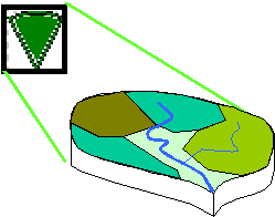
Division of a sub-basin element into hydrologic response units
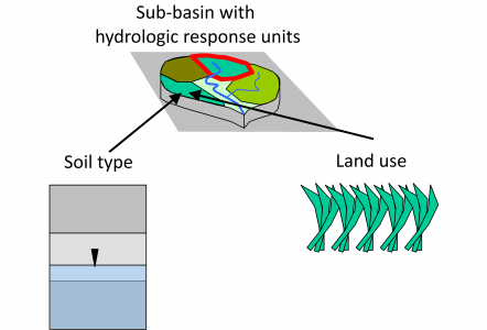
Assignment of soil type and land use to hydrologic response units

