Systemabgrenzung/en: Unterschied zwischen den Versionen
Keine Bearbeitungszusammenfassung |
Keine Bearbeitungszusammenfassung |
||
| Zeile 3: | Zeile 3: | ||
{{Navigation|vorher=|hoch=Arbeitsschritte zur Modellerstellung|nachher=Unterteilung in Systemelemente}} | {{Navigation|vorher=|hoch=Arbeitsschritte zur Modellerstellung|nachher=Unterteilung in Systemelemente}} | ||
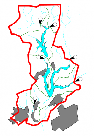
[[Datei:Eingrenzung_des_Untersuchungsgebietes.png|thumb|Example for the system boundaries of a study area]]The system boundaries of the water resources system are to be set in a way that all loads and processes which are important for the problem are represented in the model. This also includes all system states relevant for control. Often, the first definition of system boundaries is based on the boundaries of a hydrological catchment (e.g. determined in a GIS) and if necessary is extended if processes/states outside the boundaries influence the system or if information outside the catchment is to be used, e.g. for calibration. Still, the system boundaries can change due to the later devision of the system into system elements. If | [[Datei:Eingrenzung_des_Untersuchungsgebietes.png|thumb|Example for the system boundaries of a study area]]The system boundaries of the water resources system are to be set in a way that all loads and processes which are important for the problem are represented in the model. This also includes all system states relevant for control. Often, the first definition of system boundaries is based on the boundaries of a hydrological catchment (e.g. determined in a GIS) and if necessary is extended if processes/states outside the boundaries influence the system or if information outside the catchment is to be used, e.g. for calibration. Still, the system boundaries can change due to the later devision of the system into system elements. If sub-basins are mapped e.g. as external inflows by [[Special:MyLanguage/Einleitung|point source]], the system boundaries become smaller accordingly. | ||
After the system delimitation is done, the water resources system can be divided into [[Special:MyLanguage/Unterteilung in Systemelemente|system elements]]. | After the system delimitation is done, the water resources system can be divided into [[Special:MyLanguage/Unterteilung in Systemelemente|system elements]]. | ||
Version vom 22. Dezember 2020, 10:51 Uhr
The system boundaries of the water resources system are to be set in a way that all loads and processes which are important for the problem are represented in the model. This also includes all system states relevant for control. Often, the first definition of system boundaries is based on the boundaries of a hydrological catchment (e.g. determined in a GIS) and if necessary is extended if processes/states outside the boundaries influence the system or if information outside the catchment is to be used, e.g. for calibration. Still, the system boundaries can change due to the later devision of the system into system elements. If sub-basins are mapped e.g. as external inflows by point source, the system boundaries become smaller accordingly.
After the system delimitation is done, the water resources system can be divided into system elements.
